


Home > Weather > Typhoon / Asia Dust > Asia Dust > World Atlas


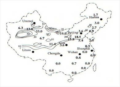
Annual frequency of dust storms in China.
DAta from Goudie (1983) are given in bigger numbers.
The desert areas of China, which occupy approximately 13% of China's total surface area, are major sources of Asian dust. These areas include the temperate arid lands from 75°E to 125°E and from 35°N to 50°N. The major wind-erosion areas are the sandy lands in western and northwestern China together with the extensive regions of the Gobi desert in northern and northeastern China, especially along the basin of the Yellow River. The Takla Makan desert is the largest desert in China, occupying 32.74×10⁴ ㎢. As a result of analyzing 30 years (1961-1990) of visibility data from 17 weather stations in the inner desert area and reaching up to 60 in the Manxiyi and Tazhongyi region.
The distribution of China's desert is closely related to the pattern of rainfall, which is in turn strongly influenced by the East-Asian and Indian summer monsoon and the moisture sources from the south, southwest and southeast. The desert in China are located in the interior of the Eurasian continent away from these moisture sources, as the high mountains to the south and west prevent the transport of moisture to these regions. In winter, the desert regions are dominated by the Siberia high-pressure system, causing then to have extremely dry and cold climates. As a combined consequency of these factors, the desert regions of China form the largest arid area in the temperate climate zone. High winds in the desert regions mobilize large quantities of dust into the atmosphere. Although much of the raised dust is deposited back upon the deserts, a substantial proportion is carried further east and deposited upon the Loess Plateau, especially along the valley of the Yellow River. Strong westerly winds may carry the dust from these regions thousands of kilometers downstream over the Pacific Ocean.
Dust storms in China may cover immense areas they mostly occur in north and northwest China in correspondence with the distribution of deserts. The Takla Makan desert has the highest dust-storm frequency, with 33 dust storms per year. The Badain Juran desert and the Loess Plateau region to the west of Beijing also has high dust-storm frequencies. Dust storms in China occur mainly in spring and winter, but most frequently in April, with one third to one half of the dust storms for each year occurring in this month. In spring, surface soils frozen in the previous winter become especially loose, creating a favorable condition for wind erosion. The springtime dust events are driven by frontal systems associated with an upper-atmospheric through located over Siberia and the northeastern part of China, known as the East-Asian trough. This trough is associated with frequent and strong cold outbreaks from the northwest, which sweep through the desert regions of China, generating large dust storms.
(Shao, 2000)
![]()
DAEJEON : GOVERNMENT COMPLEX-DAEJEON BLDG 1 11~14F, 189 CHEONGSA-RO, SEO-GU, DAEJEON,
REPUBLIC OF KOREA
SEOUL : 61 16-GIL, YEOUIDAEBANG-RO, DONGJAK-GU, SEOUL, REPUBLIC OF KOREA
Copyright(c) 2022 KMA all rights reserved. E-mail : master_kma@kma.go.kr